
My mom was a special education teacher, and that affected my trajectory towards and through adulthood in a variety of ways. One of those impacts (one of the few that doesn’t continue to come up when talking with my therapist) is my love of geography in general, and of maps specifically. The most practical reason for this is that retractable school maps – imagine your 6th grade teacher going up to the blackboard and pulling down the map of the world or the map of the United States – become less valid and relevant over time and need to be replaced. Some that went stale came home with teachers instead of going into the trash, and in my case they became the equivalent of blackout curtains in my bedroom. I remember pulling the map down when I was bored, and trying to imagine what things were like when British Honduras became Belize, or whether Salem, Oregon was named after Salem, Massachusetts or Jerusalem. These school maps were almost always focused on political geography and had a first world orientation (think Mercator projection), but they engaged my curiosity and love for maps that persists to this day.
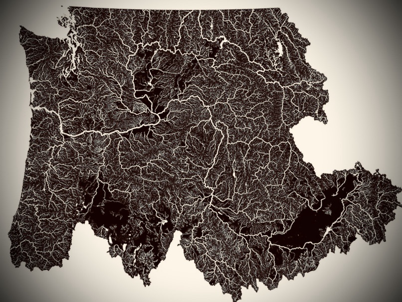
When I saw the map of the Pacific Northwest Watershed it made me smile for a variety of reasons. It still includes some elements of political geography (water that drains into the Columbia doesn’t just magically start flowing at the US/Canada border? What?) but removing some of those abstract human constructs from the map shows us some amazing things. Some folks really balk at including Idaho in the PNW, but when viewed through this lens, it’s obvious that from the natural elements that make up the area that it should be. We’re all connected, and water is that connection – metaphorically, but also practically. Dams, invasive species, boating, agriculture, fishing, native fish, what happens is upstream or downstream of someone else.

Leave a comment